 | ||
| This Photo was taken on January 28, 2016 in Pussallawa, Central, Sri Lanka | Using Samsung DSC-W710 Phone Click On This Image For Full Size Picture |

Showing posts with label Roades in Sri Lanka. Show all posts
Showing posts with label Roades in Sri Lanka. Show all posts
Thursday, March 3, 2016
Divitional Boundary
Saturday, June 20, 2015
Uva & Sabaragamuwa
 | |||
| This Photo was taken on June 21, 2015 in Marangahawela, Uva, Sri Lanka | Using Samsung SM-G360H Camera | Click On This Image For Full Size Picture |
Wednesday, June 18, 2014
1st Kilimeater Post in B 149 Road [Hatton - Maskeliya - Dalhousie(Nallathanniya) ]
 | |||
| This Photo was taken on January 23, 2014 in Hatton Central, Sri Lanka | Using Panasonic Lumix DMC-S1 Camera | Click on This Image For Full Size Picutre. |
 | |
| Google View Of This Road | Click on This Image For Full Size Picutre. |
Tuesday, June 3, 2014
At Horton Plains
 | |||
| This Photo was taken on September 13, 2013 in Horton Plains , Central, Sri Lanka. | Using Panasonic Lumix DMC-S1 Camera | Click On this Image for full Size Picture. |
Friday, April 25, 2014
Provincial Boundry in Nuwara Eliya - Welimada Road
 |
| This Photo was taken on April 18, 2013 in Hakgala, Uva, Sri Lanka. Using Panasonic Lumix DMC-S1 Camera Click On this Image for full Size Picture. |
Saturday, February 15, 2014
B593 Road In Sri Lanka
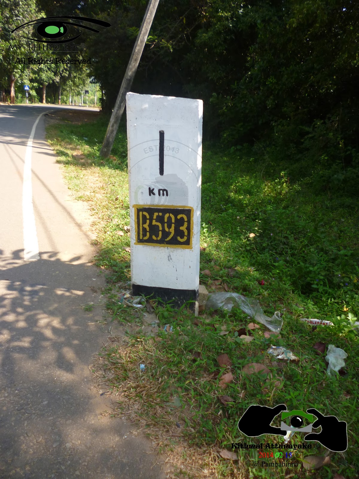 |
| This Photo was taken on February 15, 2014 in Pambahinna, Sabaragamuwa, Sri Lanka. Using Panasonic Lumix DMC-S1 Camera Click On this Image for full Size Picture. |
Discription of This Road
Road Number - B 593
Road - Pambahinna Kumbalgama Rajawaka & Kapugala
Distance - 28.42 Km
Start Elevation - 746 m
End Elevation - 722 m
Covered Areas - Sabaragamuwa Province Rathnapura District
මාර්ගය පිළිඹද විස්තරයක්
මාර්ග අංකය - B 593
මාර්ගය - පඹහින්න, කුඹල්ගම, රජවක හා කපුගල
මාර්ගයේ මුළු දුර - 28.42 Km
ආරම්භක මුහුදු මට්ටම - 746 m
අවසාන මුහුදු මට්ටම - 722 m
ආවරණය වන ප්රදේශ - සඹරගමුව පලාතේ රත්නපුර දිස්ත්රික්කය
 |
| Google View of This Road Click On this Image for full Size Picture |
Friday, November 22, 2013
Divitional Boundry - Badulla & Monaragala
 |
| This Photo was taken on November 16, 2013 in Wellawaya, Uva, Sri Lanka. Using Panasonic Lumix DMC-S1 Camera Click On this Image for full Size Picture. |
Sunday, October 27, 2013

Tuesday, October 22, 2013
A 16 Road In Sri Lanka
 |
| This Photo was taken on Octomber 16, 2013 in Bandarawela, Uva, Sri Lanka. Using Panasonic Lumix DMC-S1 Camera Click On this Image for full Size Picture. |
Road Number - A 16
Road - Beragala - Hali - Ela
Distance - 40.39 Km
Start Elevation - 986m
End Elevation - 772m
Covered Areas - Uva Province Badulla District
මාර්ගය පිළිඹද විස්තරයක්
මාර්ග අංකය - A 16
මාර්ගය - බෙරගල - හාලිඇල
මාර්ගයේ මුළු දුර - 40.39 Km
ආරම්භක මුහුදු මට්ටම - 986m
අවසාන මුහුදු මට්ටම - 772m
ආවරණය වන ප්රදේශ - ඌව පලාතේ බදුල්ල දිස්ත්රික්කය
 |
Google View of This Road Click On this Image for full Size Picture. |
Sunday, September 29, 2013
B 508 Road in Sri Lanka
 |
| This Photo was taken on September 10, 2013 in Ohiya, Uva, Sri Lanka. Using Panasonic Lumix DMC-S1 Camera Click On this Image for full Size Picture. |
Road Number - B 508
Road - Welimada, Boralanda, Ohiya & Horton Plains
Distance - 32.47 Km
Start Elevation - 1051m
End Elevation - 2130m
Covered Areas - Uva Province Badulla District & Central Province Nuwara Eliya District
මාර්ගය පිළිඹද විස්තරයක්
මාර්ග අංකය - B 508
මාර්ගය - වැලිමඩ, බොරලන්ද, ඔහිය හා හෝර්ටන්තැන්න
මාර්ගයේ මුළු දුර - 32.47 Km
ආරම්භක මුහුදු මට්ටම - 1051m
අවසාන මුහුදු මට්ටම - 2130m
ආවරණය වන ප්රදේශ - ඌව පලාතේ බදුල්ල දිස්ත්රික්කය හා මධ්යම පලාතේ නුවර එළිය දිස්ත්රික්කය
 |
| Google View of This Road Click On this Image for full Size Picture. |
Subscribe to:
Posts (Atom)